Garmin BlueChart® g3 Vision® HD - VCA008R - Newfoundland West - microSD*/SD*
BlueChart® g3 Vision® HD - VCA008R - Newfoundland West - microSD™/SD™
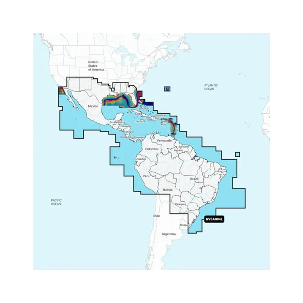
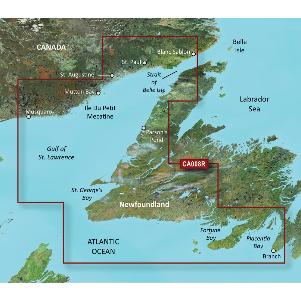
Coverage:
Covers the western and southern coast of New Foundland from the Strait of Belle Isle to Placentia Bay, including St. George's Bay and Fortune Bay. Also covers the coasts of Quebec and Labrador from La Romaine to Red Bay.
Premier Coastal Charts
- Industry-leading coverage, clarity and detail with updated coastal charts that feature integrated Garmin and Navionics® content
- Auto Guidance¹ technology quickly calculates a suggested route by using your desired depth and overhead clearance
- Includes Depth Range Shading for up to 10 depth ranges, enabling you to view your target depth at a glance
- Up to 1’ contours provide a more accurate depiction of the bottom structure for improved fishing charts
- To give a clear picture of shallow waters to avoid, the Shallow Water Shading allows for shading at a user-defined depth
Experience unparalleled coverage and brilliant detail when you’re on the water. BlueChart g3 Vision coastal charts provide industry-leading coverage, clarity and detail with integrated Garmin and Navionics content.
Auto Guidance
Whether you are fishing or cruising, select a spot, and get a route showing you the general path and nearby obstructions at a safe depth1.
Depth Range Shading
This feature displays high-resolution Depth Range Shading for up to 10 depth ranges so you can view your designated target depth.
Shallow Water Shading
To give a clear picture of shallow waters to avoid, this feature allows for shading at a user-defined depth.
Detailed Contours
BlueChart g3 Vision charts feature 1’ contours that provide a more accurate depiction of bottom structure for improved fishing charts and enhanced detail in swamps, canals and port plans.
High-resolution Satellite Imagery
High-resolution satellite imagery with navigational charts overlaid gives you a realistic view of your surroundings. It’s our most realistic charting display in a chartplotter — ideal for entering unfamiliar harbors or ports.
FishEye View
This underwater perspective shows 3-D representation of bottom and contours as seen from below the waterline. Interface with sonar data for a customized view.
MarinerEye View
This view provides a 3-D representation of the surrounding area both above and below the waterline.
Aerial Photography
Crystal-clear aerial photography shows exceptional detail of many ports, harbors and marinas and is ideal when entering unfamiliar ports.
¹Auto Guidance is for planning purposes only and does not replace safe navigation practices
WARNING: This product can expose you to chemicals which are known to the State of California to cause cancer, birth defects or other reproductive harm. For more information go to P65Warnings.ca.gov.
This product may not be returned to the original point of purchase. Please contact the manufacturer directly with any issues or concerns.Explore the stunning coastal waters of Newfoundland West with the Garmin BlueChart® g3 Vision® HD (Part Number: 010-C0694-00). This microSD*/SD* card provides premier coverage from the Strait of Belle Isle to Placentia Bay, including St. George's Bay and Fortune Bay, as well as the coasts of Quebec and Labrador from La Romaine to Red Bay. Experience industry-leading clarity and detail in your navigation with integrated Garmin and Navionics? content, perfect for both fishing and cruising enthusiasts.
Features:
* Coverage: Covers the western and southern coast of Newfoundland and the coasts of Quebec and Labrador.
* Premier Coastal Charts: Features updated coastal charts with integrated Garmin and Navionics? content for clarity and detail.
* Auto Guidance: Quickly calculates a suggested route using your desired depth and overhead clearance.
* Depth Range Shading: Displays high-resolution Depth Range Shading for up to 10 depth ranges for easy target depth viewing.
* Shallow Water Shading: Allows for shading at a user-defined depth to highlight shallow waters to avoid.
* Detailed Contours: 1* contours provide an accurate depiction of bottom structure, enhancing fishing charts.
* High-resolution Satellite Imagery: Overlays navigational charts with high-resolution satellite imagery for a realistic view.
* FishEye View: 3-D representation of bottom contours, interfacing with sonar data for a customized underwater perspective.
* MarinerEye View: Visualizes the surrounding area above and below waterline in 3-D.
* Aerial Photography: Crystal-clear aerial imagery delivers exceptional detail of ports, harbors, and marinas.
BlueChart® g3 Vision® HD - VCA008R - Newfoundland West - microSD™/SD™
Coverage:
Covers the western and southern coast of New Foundland from the Strait of Belle Isle to Placentia Bay, including St. George's Bay and Fortune Bay. Also covers the coasts of Quebec and Labrador from La Romaine to Red Bay.
Premier Coastal Charts
- Industry-leading coverage, clarity and detail with updated coastal charts that feature integrated Garmin and Navionics® content
- Auto Guidance¹ technology quickly calculates a suggested route by using your desired depth and overhead clearance
- Includes Depth Range Shading for up to 10 depth ranges, enabling you to view your target depth at a glance
- Up to 1’ contours provide a more accurate depiction of the bottom structure for improved fishing charts
- To give a clear picture of shallow waters to avoid, the Shallow Water Shading allows for shading at a user-defined depth
Experience unparalleled coverage and brilliant detail when you’re on the water. BlueChart g3 Vision coastal charts provide industry-leading coverage, clarity and detail with integrated Garmin and Navionics content.
Auto Guidance
Whether you are fishing or cruising, select a spot, and get a route showing you the general path and nearby obstructions at a safe depth1.
Depth Range Shading
This feature displays high-resolution Depth Range Shading for up to 10 depth ranges so you can view your designated target depth.
Shallow Water Shading
To give a clear picture of shallow waters to avoid, this feature allows for shading at a user-defined depth.
Detailed Contours
BlueChart g3 Vision charts feature 1’ contours that provide a more accurate depiction of bottom structure for improved fishing charts and enhanced detail in swamps, canals and port plans.
High-resolution Satellite Imagery
High-resolution satellite imagery with navigational charts overlaid gives you a realistic view of your surroundings. It’s our most realistic charting display in a chartplotter — ideal for entering unfamiliar harbors or ports.
FishEye View
This underwater perspective shows 3-D representation of bottom and contours as seen from below the waterline. Interface with sonar data for a customized view.
MarinerEye View
This view provides a 3-D representation of the surrounding area both above and below the waterline.
Aerial Photography
Crystal-clear aerial photography shows exceptional detail of many ports, harbors and marinas and is ideal when entering unfamiliar ports.
¹Auto Guidance is for planning purposes only and does not replace safe navigation practices
WARNING: This product can expose you to chemicals which are known to the State of California to cause cancer, birth defects or other reproductive harm. For more information go to P65Warnings.ca.gov.
This product may not be returned to the original point of purchase. Please contact the manufacturer directly with any issues or concerns.Explore the stunning coastal waters of Newfoundland West with the Garmin BlueChart® g3 Vision® HD (Part Number: 010-C0694-00). This microSD*/SD* card provides premier coverage from the Strait of Belle Isle to Placentia Bay, including St. George's Bay and Fortune Bay, as well as the coasts of Quebec and Labrador from La Romaine to Red Bay. Experience industry-leading clarity and detail in your navigation with integrated Garmin and Navionics? content, perfect for both fishing and cruising enthusiasts.
Features:
* Coverage: Covers the western and southern coast of Newfoundland and the coasts of Quebec and Labrador.
* Premier Coastal Charts: Features updated coastal charts with integrated Garmin and Navionics? content for clarity and detail.
* Auto Guidance: Quickly calculates a suggested route using your desired depth and overhead clearance.
* Depth Range Shading: Displays high-resolution Depth Range Shading for up to 10 depth ranges for easy target depth viewing.
* Shallow Water Shading: Allows for shading at a user-defined depth to highlight shallow waters to avoid.
* Detailed Contours: 1* contours provide an accurate depiction of bottom structure, enhancing fishing charts.
* High-resolution Satellite Imagery: Overlays navigational charts with high-resolution satellite imagery for a realistic view.
* FishEye View: 3-D representation of bottom contours, interfacing with sonar data for a customized underwater perspective.
* MarinerEye View: Visualizes the surrounding area above and below waterline in 3-D.
* Aerial Photography: Crystal-clear aerial imagery delivers exceptional detail of ports, harbors, and marinas.
Description
BlueChart® g3 Vision® HD - VCA008R - Newfoundland West - microSD™/SD™
Coverage:
Covers the western and southern coast of New Foundland from the Strait of Belle Isle to Placentia Bay, including St. George's Bay and Fortune Bay. Also covers the coasts of Quebec and Labrador from La Romaine to Red Bay.
Premier Coastal Charts
- Industry-leading coverage, clarity and detail with updated coastal charts that feature integrated Garmin and Navionics® content
- Auto Guidance¹ technology quickly calculates a suggested route by using your desired depth and overhead clearance
- Includes Depth Range Shading for up to 10 depth ranges, enabling you to view your target depth at a glance
- Up to 1’ contours provide a more accurate depiction of the bottom structure for improved fishing charts
- To give a clear picture of shallow waters to avoid, the Shallow Water Shading allows for shading at a user-defined depth
Experience unparalleled coverage and brilliant detail when you’re on the water. BlueChart g3 Vision coastal charts provide industry-leading coverage, clarity and detail with integrated Garmin and Navionics content.
Auto Guidance
Whether you are fishing or cruising, select a spot, and get a route showing you the general path and nearby obstructions at a safe depth1.
Depth Range Shading
This feature displays high-resolution Depth Range Shading for up to 10 depth ranges so you can view your designated target depth.
Shallow Water Shading
To give a clear picture of shallow waters to avoid, this feature allows for shading at a user-defined depth.
Detailed Contours
BlueChart g3 Vision charts feature 1’ contours that provide a more accurate depiction of bottom structure for improved fishing charts and enhanced detail in swamps, canals and port plans.
High-resolution Satellite Imagery
High-resolution satellite imagery with navigational charts overlaid gives you a realistic view of your surroundings. It’s our most realistic charting display in a chartplotter — ideal for entering unfamiliar harbors or ports.
FishEye View
This underwater perspective shows 3-D representation of bottom and contours as seen from below the waterline. Interface with sonar data for a customized view.
MarinerEye View
This view provides a 3-D representation of the surrounding area both above and below the waterline.
Aerial Photography
Crystal-clear aerial photography shows exceptional detail of many ports, harbors and marinas and is ideal when entering unfamiliar ports.
¹Auto Guidance is for planning purposes only and does not replace safe navigation practices
WARNING: This product can expose you to chemicals which are known to the State of California to cause cancer, birth defects or other reproductive harm. For more information go to P65Warnings.ca.gov.
This product may not be returned to the original point of purchase. Please contact the manufacturer directly with any issues or concerns.Explore the stunning coastal waters of Newfoundland West with the Garmin BlueChart® g3 Vision® HD (Part Number: 010-C0694-00). This microSD*/SD* card provides premier coverage from the Strait of Belle Isle to Placentia Bay, including St. George's Bay and Fortune Bay, as well as the coasts of Quebec and Labrador from La Romaine to Red Bay. Experience industry-leading clarity and detail in your navigation with integrated Garmin and Navionics? content, perfect for both fishing and cruising enthusiasts.
Features:
* Coverage: Covers the western and southern coast of Newfoundland and the coasts of Quebec and Labrador.
* Premier Coastal Charts: Features updated coastal charts with integrated Garmin and Navionics? content for clarity and detail.
* Auto Guidance: Quickly calculates a suggested route using your desired depth and overhead clearance.
* Depth Range Shading: Displays high-resolution Depth Range Shading for up to 10 depth ranges for easy target depth viewing.
* Shallow Water Shading: Allows for shading at a user-defined depth to highlight shallow waters to avoid.
* Detailed Contours: 1* contours provide an accurate depiction of bottom structure, enhancing fishing charts.
* High-resolution Satellite Imagery: Overlays navigational charts with high-resolution satellite imagery for a realistic view.
* FishEye View: 3-D representation of bottom contours, interfacing with sonar data for a customized underwater perspective.
* MarinerEye View: Visualizes the surrounding area above and below waterline in 3-D.
* Aerial Photography: Crystal-clear aerial imagery delivers exceptional detail of ports, harbors, and marinas.